1km Basemap Pack Tutorial:
The 1km Basemap Pack is used for 'tracing' contours, roads etc. over, to enable easier positioning of items on prototypical layouts
- Download 1km Basemap Pack v1 (275k) .cdp file here, or from the Trainz Download Station using this link: 1km Basemap Pack
- Scan a printed map of the area you wish to make your Trainz layout from.
- Using a Photo Editing program (Photoshop, Paint Shop Pro etc.), copy an area of the map at the 1km grid square lines to the clipboard
- Create a new image
- Paste the copied map to the new image
- Resize to 1024x1024 pixels
- Save the new image to your hard disk over the Basemap file '1km square X.jpg' where 'X' is the letter A-I appropriate to the section of map being used - See picture below. (1km Basemap files are normally stored in directories "C:\Program Files\Auran\TRS2004\World\Custom\Scenery\1km Basemap A" to "..\1km Basemap I")
NOTE: Your scanned map file must have the same name as the basemap square file it is replacing.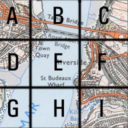
- Repeat for all sections (A-I) you wish to use
- Restart Trainz
- In Surveyor, add the Basemap objects (from the Scenery section) to your layout
- Change the view to grid lines only (the button at the top right in Surveyor that looks like a silver waffle)
- Raise or lower the height of the Basemap as necessary, so you can see the picture of the map you have scanned
- Trace contour lines, roads, track layouts as required
- When you have finished tracing over the Basemaps, delete them from your layout
- The reason the pack consists of 9 individual Basemaps, is so all 8 squares around the one you're working on can be seen, and you can continue from one to another.
- NOTE: Depending on the scale of your baseboards, these 1km squares will probably be larger than 1 board. (Why Auran chose baseboards 720mx720m is anyone's guess. I've never come across a map with grid lines at 720m intervals!)